
| Winter
2017-18 #24 |
|
|
Best
articles |
Previous
News 20022017 |
|
||||
|
||||
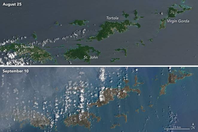
2017: Most damaging year ever for Atlantic hurricanesMore than 1000 deaths in the USA and Caribbean See a Chart of the paths of all Atlantic Hurricanes in 2017. The year just ended was the most active year for Atlantic hurricanes since Hurricane Katrina flooded most of New Orleans in 2005. The US National Hurricane Center tracked 17 named storms (ten hurricanes and seven more tropical storms) in the Atlantic in 2017. Their Hurricane Tracking Chart (shown on another page) depicts a stormy Gulf of Mexico and the Atlantic just offshore of the eastern USA and Canada. Six of the ten hurricanes became major storms in categories 3, 4, or 5, in which peak wind speeds exceeded 111, 130, or 157 miles per hour, respectively. Winds greater than 110 mi./hr. will wreak significant damage to homes, businesses, trees and power lines. A table of wind damage (below, at right) of the National Hurricane Center lists the likely damage to homes from hurricane winds in category 3, 4, and 5 storms. The three major hurricanes that entered the United States killed at least 234 persons, and destroyed hundreds of billions of dollars worth of property. Hurricane Harvey barged into Texas as a category 4 storm, but as its winds diminished, it unleashed torrential rains totaling 40 to 61 inches (one to 1 ½ meters of water depth) over several days4. Harvey effectively washed out Greater Houston. In September, category-5 Hurricane Irma demolished ten Caribbean island nations or territories, including the Virgin Islands, then breezed up the entire length of Florida as a category-4 storm. Hurricane Maria (also category 5) devastated the Virgin Islands at first, then all of Puerto Rico. Over 95% of the 3.4 million American citizens of Puerto Rico lost electricity and piped water for months. At year's end, 100 days after Maria blew through, more than one-half of the commonwealth was getting by without electric power, according to the New York Times. In contrast, 92% of electric customers in the Virgin Islands had electricity at year's end.
The impact on human lifeThese three hurricanes killed a lot of people in several countries and territories: Harvey killed at least 84 persons, and Irma, 95. Puerto Rican authorities gave an official death count of 55 from Hurricane Maria at the end of November, though officials readily admit this is an undercount. Maria, though, is said to have indirectly led to the death of over 1000 from the lack of electricity and running water for many months. Two social scientists, Alexis Santos, at Pennsylvania State University, and Jeffrey Howard, a health scientist, estimate Maria's indirect death toll to be 1,085 or more in Puerto Rico alone (according to vox.com3). This is double the previous record of 500 deaths that resulted from the floods of Hurricane Katrina in 2005.6 Santos and Howard culled the Vital Statistics of Puerto Rico to compare the number of deaths in September and October 2017 to the historical average of deaths in September and October in the previous seven years. For this year, they counted only the deaths reported by the Puerto Rico Department of Public Safety. There was an excess of more than one thousand deaths in 2017 in those two months. The cost in damagesMaria, Harvey, and Irma together created the most devastation the United States has ever experienced in one year from hurricanes since, arguably, the great Galveston hurricane of 1900: damages in the USA alone amounted to $265 billion (with a b)—the highest on record. 2 Damages from Katrina twelve years ago amounted to $215 billion (adjusted for inflation) that the federal government and private and federal insurance programs spent. That is less than people are paying for damages from the three major hurricanes of 2017. Damages from all kinds of severe weather events in 2017, at 306 billion dollars, also set an all-time record for this country.6 |
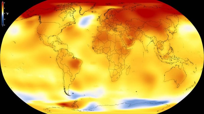
Climate News in the new year2017: Most severe hurricane season in over a century (UPDATED)2017: Second warmest year ever observed on EarthCarbon emissions spiked in 2017 after remaining stable for 3 years“We must Defend Science!” in this age of post-truthEl Niño inflamed an epidemic of Zika virus that spread rapidlyOutlook for Spring 2018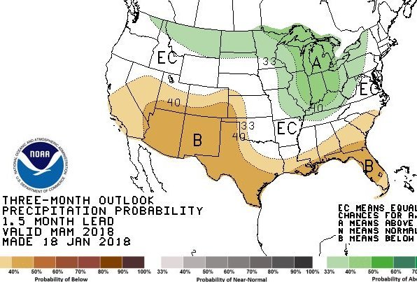 The spring outlook for temperatures (in March, April, and May, 2018) is similar to the forecast previously given for the winter of 2017-18: warmer than normal for the season in the southern half of the USA as well as along the entire east coast; but cooler than normal in the Northwest. The ongoing La Niña is responsible for this pattern. We did not depict this here, but a map of it is available from the Climate Prediction Center, which is part of the US National Weather Service. The above map presents the outlook for precipitation in the upcoming spring. The Great Lakes region and Ohio valley can expect a high probability of a wet spring. Meanwhile, ongoing dry conditions are expected in the Southwest US and the entire Gulf Coast. The ongoing La Niña is partly responsible for the expected dry spring in the southern states, but agreement among several seasonal climate prediction models has strengthened the confidence of forecasters in this outlook. 2017: Second warmest year ever observedThe year that just ended was the second warmest ever measured on Earth, according to scientists at NASA. The previous year, 2016, remains as the warmest year in the record. The year 2017 was also the third year in a row in which the global average temperature surpassed 1ºC (1.8ºF) above the global averages measured in the late 19th century, when the industrial era was beginning in earnest. Although they disagree on the ranking of the year 2017, both NASA and the National Oceanic and Atmospheric Administration (NOAA) agree that the five warmest years on record all have taken place since 2010.
|
|||||||||||||||||||
SOURCES:
See a CHART of paths and intensities of all Atlantic Ocean hurricanes in 2017.
|
|