|
A
New Normal: Frequent Catastrophic Flooding
|

|
When its two rivers
flooded, Calgary, Alberta had to evacuate its entire downtown
area on June 21 of this year. That flooding caused three deaths
and the displacement of over 100,000 people in the Canadian
province (from the Minneapolis Star-Tribune). (See
story below, “A record wet spring
of 2013.”)
“FDR dispatched
thousands of relief workers. In a landscape fraught with dangers—from
unmoored gas tanks that became floating bombs to powerful
currents of filthy floodwaters that swept away whole towns—people
hastily raised sandbag barricades, piled into overloaded rowboats,
and marveled at water that stretched as far as the eye could
see.
“The overflow
surpassed all estimations of the Ohio's potential strength.
At one point the river's entire 981-mile run stood above flood
stage. Buildings, farms, and cities . . . disappeared beneath
the waves. Water covered 15,000 miles of highway. . . . .
. . . Hundreds of people drowned or died from pneumonia and
other illnesses.”
(From
the book, “The Thousand-Year Flood”
by David Welky (1).) more
|
| A
100-year flood is expected once in a century, by definition —
but that is true for the 20th century when climate statistics
were compiled. As the climate warms and the wet or dry patterns
of rainfall change, hydrologists are revising predictions for
how often a serious river flood of this magnitude might recur
in the 21st century. A new estimate (2) published
in Nature Climate Change by Y. Hirabayashi and his team
at the University of Tokyo predicts that a current 100-year flood
will recur much more frequently later this century (from 2070
to 2100) in much of south and southeast Asia, wet equatorial Africa,
eastern Siberia, the northern Andes, and the intensive farm belts
of Argentina and Brazil. Their prediction of more frequent river
flooding is robust for areas influenced by the Asian summer monsoon
(southern India, Indochina and southern China), and for the farm
belts in South America. Hirabayashi’s team calculated that
a current “100-year flood” can be expected to recur
every 10 to 20 years (about five times more frequently than now)
in some regions. |
|
|
In
contrast, they predict a drier climate and less frequent flooding
in most of Europe, the central states and southern Rocky Mountains
of the USA, central Asia from Turkey to Pakistan, and far southern
South America. For example, the Danube River basin in Europe
is projected to dry out: a 100-year flood would recur only about
every 250 years in the new climate. more
|
A Swiss-Austrian
team finds that until 2020, there is a "window"
of greenhouse gas emissions that would still limit global
warming to 2°C over the long term. That window does
not stay open for long. Story
here. |
|
We refer only to floods on rivers, not coastal flooding caused
by storm surge or battering waves on a seashore. A once-in-a-century
river flood is said to have a "return period" of 100 years,
and its magnitude depends on the river's basin, as well as
the local climate. In the years 2070 to 2100, under the most
extreme of four cases of human climate alteration, a current
100-year flood would recur more often on 42% of the world's
land. It would recur less often on another 18% of the land
area. More than half of the climate models predicted this
increase for places where flooding will become more frequent;
that gave the research team more confidence that their prediction
is valid.
Rather than using
a single global climate model linked to a single river runoff
model, Hirabayashi's team assembled results from 11 different
climate models, to gain more confidence in the overall result.
For each model, they obtained simulations that assume four
different pathways for future human emissions of greenhouse
gases. In their summary, they only reported conclusions based
on one pathway leading to the "most dangerous outcomes"
(in their words) for climate: a pathway (3)
in which industrial societies do not limit greenhouse gases
at all before the year 2100.
When the team projected
future return periods for a flood now considered to be a 100-year
event, the various models projected dramatically shorter return
periods for a few rivers: as short as 5 years for the Nile
River, and about 10 years for Africa's Congo, and the Mekong,
Ganges, and Brahmaputra Rivers in Asia.
|
|
Other students of natural disasters
proposed the concept of flood exposure to measure the number
of people living in inundation zones of floods large enough
to have a return period of 100 years in the present climate.
The recent flood exposure of the world's people was 15 million,
for the years 1980-1999. The flood exposure started to rise
in 1996 after remaining flat for many decades.
Keeping the population constant at
what it was in 2005, but allowing climate to change and rivers
to flood more or less often as rainfall patterns changed, Hirabayashi's
team estimated that 27 million people would be exposed to floods
of this size by the year 2100, if the global climate warms by
2°C above the average for 1980-1999. (Two degrees of warming
is the maximum that might avoid "dangerous interference in the
climate," according to many scientific bodies.) And if it should
warm by 6°C, or three times as much, then 93 million people
would be living in the way of such catastrophic floods.
CITATIONS:
1. David Welky,
“The Thousand-Year Flood: The Ohio-Mississippi Disaster
of 1937”, book, 384 pp., © 2011. University
of Chicago Press.
2. “
Global flood risk under climate change,” by Y. Hirabayashi
and colleagues, Nature Climate Change, published
online 9 June 2013, Doi: 10.1038/NCLIMATE1911.
3. These pathways
are termed “representative concentration pathways”
(RCP) and are summarized in: “The
representative concentration pathways: an overview”
by D.P. van Vuuren and 14 colleagues, Climatic Change,
vol. 109, 5-31, Dec. 2011,
DOI: 10.1007/s10584-011-0148-z.
next story (
News headlines)
|
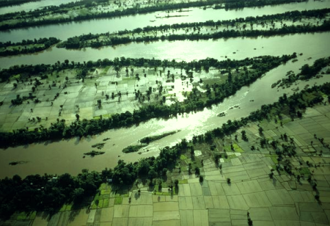 Mekong River in a typical flood
A
record wet spring of 2013 in central US
“This is the worst spring I can remember in my 30
years farming. Just continuous rain, not having an opportunity
to plant,” said Rob Korff of Missouri, who planted his
corn a month late because of the weather.” (Minneapolis
Star-Tribune, June 1, 2013).
Iowa had its wettest spring ever in
2013 with 18 inches of precipitation, twice the 3-month normal
amount. Very wet conditions were the rule in five other neighboring
states (rainfall map, below).
(From State
of the Climate:
synoptic discussion for May 2013, published online June
2013, NOAA/ National Climatic Data Center.
|
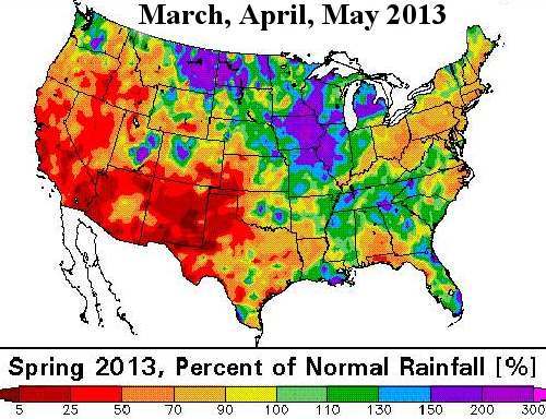 Credit: US National Climatic Data Center
|
|
|