Summer
2011 Forecast
La Niña no Longer Rules!
The La Niña phase of the El Nino-Southern Oscillation (ENSO) finally expired by the first days of June 2011. La Niña has been responsible for a prolonged drought in the Southwest and Southeast United States, at the same time that it favored heavy snowfall and rainfall in the upper Midwest and Northwest, in the winter and spring seasons ending on June 1. The surface of the equatorial Pacific Ocean now is observed to have normal temperatures over a wide area, which indicates that ENSO is in a “neutral” phase. (The ENSO phenomenon is commonly called “El Niño” in its warm phase and “La Niña” in its cold phase.) There are strong indications that the neutral ENSO will persist from now through the northern winter of 2011–2012.
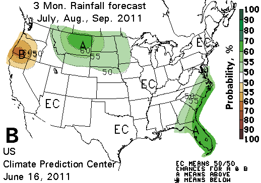
In the northern High Plains, where the temperature map (A, right) has blue tones, the US Climate Prediction Center (CPC) is forecasting a cool summer or late summer (July, August, and September 2011) , due to very wet soil in the region. The wet ground also supports a forecast of a rainy summer in the same region (precipitation forecast in second map, below). La Niña was largely responsible for the very wet and snowy conditions in the High Plains and northern Rockies in the last six months. The Northwest had its wettest spring season on record, with precipitation 160% of normal from March to May.
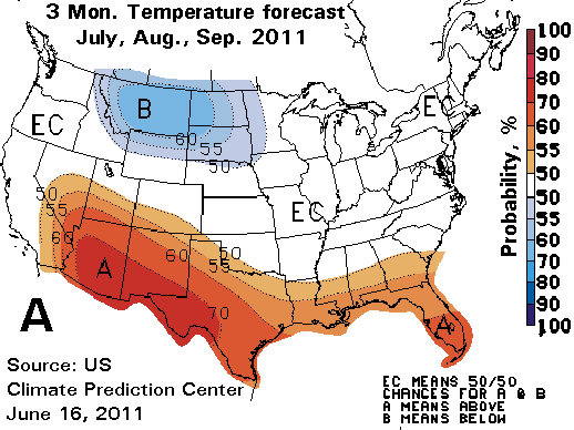
The CPC forecasts a hotter-than-normal season in the southern swath of the nation from Arizona and Las Vegas all the way to Florida (area of orange tones on A, above). This is based on trends they have observed in the Southwestern and Southeastern US over several decades. Whether related to global warming or not, the summer season climate has measurably warmed in these regions. Some may find relief in the precipitation forecast (map B, below) which indicates that nothing out of the ordinary is expected for these three months in the South, except in Florida and coastal areas of the southeastern US, where it is expected to be wet.
Interestingly, western Oregon is predicted to be drier than normal, unlike Montana. Both regions endured six months of well-above-average precipitation (130% to 160% of normal) last winter and spring, but the forecast for Oregon is based not on soil moisture, but on trends noticed in recent decades in the summer season.
Trends also underpin the forecast of a warmer-than-normal summer in northern Alaska. The rapidly warming Arctic climate has been noted and commented on by the Arctic Climate Impact Assessment and the IPCC, or Intergovernmental Panel on Climate Change.
Monthly and seasonal forecasts are now based on a new 30-year averaging period, 1981–2010. The new averages of temperature, precipitation, and other observed elements of the weather, called "climate normals," were released to the public recently on July 1. The new normals document that warming in the United States is now extensive and has been underway for more than thirty years. Watch for a report in the next few days on NOAA's new climate normals on this site.